Walk #1 – Nature Trail within Lainshaw Woods
This walk is largely within the Lainshaw Woods. Please see the Nature Trail Map for details.
Walk #2 – Millhouse to Lainshaw Woods
This walk starts at the Millhouse on the Old Glasgow Road and finishes at the exit from the Lainshaw Woods on Kilwinning Road. Please note that, at that particular exit from Lainshaw Woods, the Kilwinning Road is a rural road with no pavement or footpath.
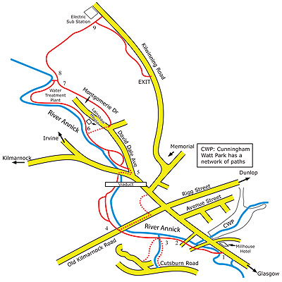
- Section 1: Millhouse to Springwell Place: From the Millhouse head north up the Old Glasgow Road for a short distance and take the first right turn into Gilbert Sheddon Court. Then turn right immediately after crossing the bridge and follow the cycle path beside the Annick Water.
- Section 2: Springwell Place to Cutsburn Road: From the bridge at Springwell Place, staying on the same side of the river, follow the path for approximately 180 metres to the wooden Cutsburn Bridge. Turn left before the Cutsburn Bridge and follow the cycle path up to Cutsburn Road.
- Section 3: Cutsburn Bridge to Kirkford Bridge: An alternative route at the Cutsburn Bridge. Cross the Cutsburn Bridge and follow the riverside cycle path until it meets the Kirkford Bridge at Old Kilmarnock Road.
- Section 4: Kirkford Bridge to Railway Viaduct: Cross Old Kilmarnock Road and go down the footpath beside the last sandstone house, again on the same side of the river. Cross the small bridge over the burn and after 40 metres the path splits, one going left away from the river and the other following the river bank. When the two paths merge, follow the river for 100 metres under the railway viaduct until meeting Kilmarnock Road. Cross Kilmarnock Road with care and turn right. After 30 metres turn left into David Dale Avenue. This path can be wet at times, alternatives are up the Vennel to Stewarton Cross and turn left along Lainshaw Street or through the Church Yard and turn left along Lainshaw Street.
- Section 5: Railway Viaduct to Fisherman’s Path: At the metal barrier at the start of David Dale Avenue, go down the zig-zag slope and across the small bridge and then along the riverside. Follow the path as it turns left after a slight slope and continue along the river until the edge of the woods. The trees in this area are mainly Beech and Chestnut. At this point you can turn right to access the tarmac road to the water treatment works. *Wheelchair users should use this route to avoid the steps*
- Section 6: Fisherman’s Path to The New Steps: The path still follows the river below Lainshaw House and continues into the woods. Follow the path until it comes into a clearing at the water treatment works, then follow the path as it contours round the works and continues on a straight line until meeting a set of steps. Go up the steps until meeting another path where you have a choice of right to David Dale Avenue or left towards Kilwinning Road.
- Section 7: Walled Garden to David Dale Avenue: At the top of the steps turn right and join the tarmac road which passes the Walled Garden heading back into Stewarton meeting the path at the end of route 5. *This is the path wheelchair users should take between sections 5 and 8*
- Section 8: The New Steps to Kilwinning Road: At the top of the steps turn left and follow the path slightly downhill and then round to the right before a long straight stretch going uphill to the top at Anderson’s Mount. At the top, near the seat, there are two alternative rougher paths going left and right along the edges of the wood. The main path goes straight on and after a slight curve in the path goes back downhill to a culvert then ascends in a straight line to the first Kilwinning Road exit.
- Section 9: Plantation Path along Kilwinning Road: At this point the path turns right and runs parallel to Kilwinning Road back towards Stewarton. In this area the trees are mainly Birch, Pine and Beech. The path curves through the woods until the second Kilwinning Road exit at the SWAT gate.
Walk #3 – Extended, Circular Walk Around Stewarton
This walk takes in the banks of Annick Water, Lainshaw Woods and Cunningham Watt Park. Approximately 4.6 miles in length, it takes most walkers just under 2 hours to complete. Please see Gillian’s Walks for details.
Walk #4 – Clerkland Burn Path
This walk is a subset of Walk #3 and focuses on the Clerkland Burn as it enters the town and passes through Cunningham Watt Park. See the All Trails website for details.
We hope you get a chance to explore and enjoy some of these paths. Please follow the Scottish Outdoor Access Code (previously the ‘Country Code’).